
Tsingy de Bemaraha National Park – one of Madagascar’s most spectacular geological wonders
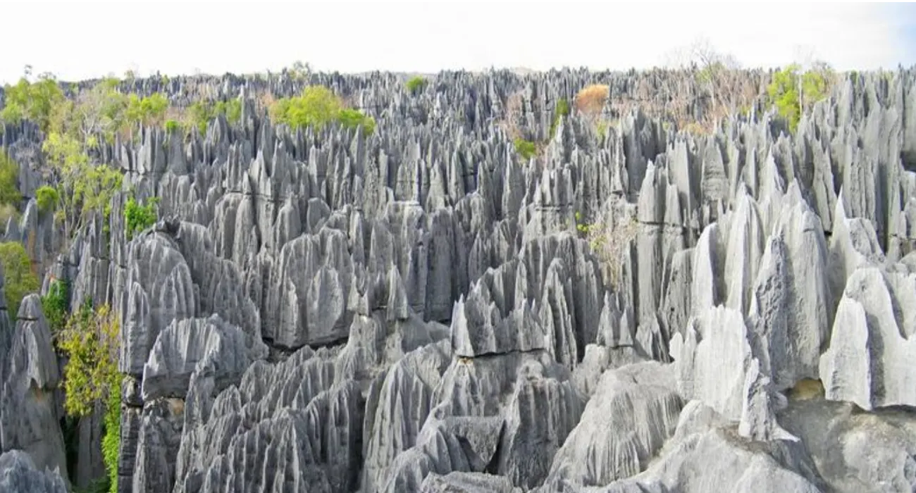
Tsingy de Bemaraha National Park is one of Madagascar’s most spectacular landscapes, inscribed as a UNESCO World Heritage Site. It is famous for its breathtaking limestone tsingy formations – true forests of rock blades and spires rising above the dry western plateau of Madagascar.
Isolated and more difficult to reach than other parks, Tsingy de Bemaraha attracts adventure-seeking travelers: suspended bridges, narrow passages between the tsingy, pirogue excursions on the Manambolo River, as well as lemur watching, endemic birds and plants adapted to rock and drought.
Geography and landscapes of the park
Tsingy de Bemaraha National Park is located in the Melaky region, in western Madagascar, north of Morondava, near the village of Bekopaka.
- Area: approximately 152,000 ha (park and integral reserve).
- Geological origin: ancient marine limestone plateau, sculpted by erosion into tsingy pinnacles.
- Terrain: extensive tsingy fields, deep canyons, sinkholes, caves and cliffs overlooking the Manambolo River valley.
- Altitude: between approximately 150 and 750 m.
- Climate: tropical dry, with rainy season (December–March) and long dry season (April–November); marked daytime heat.
The contrast between the bare rock of the plateaus and the wooded gorges creates a striking and very scenic landscape.
Trails and circuits
Access to the tsingy is via circuits equipped with ladders, handrails and suspended bridges, always with a mandatory guide:
Little Tsingy (near Bekopaka)
A few-hour trails in a more accessible tsingy area, with viewpoints, caves and lemur watching.
Grand Tsingy
Longer and physically challenging itineraries, including sections on the “surface” of the tsingy, suspended bridges and technical passages with harnesses.
Manambolo River excursion
A pirogue trip to admire cliffs, caves and ancient Sakalava burial sites.
Dry forest and canyon trails
More relaxed walks to observe wildlife and flora away from the busier areas.
Some circuits require no fear of heights, familiarity with ladders and exposed passages, and a certain agility in narrow rocky corridors.
Wildlife
Despite its mineral appearance, Tsingy de Bemaraha hosts a surprisingly rich fauna.
Key species:
- Decken’s sifaka (Propithecus deckenii), a white dry-forest lemur, often visible at forest edges and in canyons
- Red-fronted brown lemur (Eulemur rufus)
- Various nocturnal lemurs (e.g. Avahi and Microcebus species of the west)
- Madagascar fish eagle (Haliaeetus vociferoides), a highly threatened species, sometimes observed on cliffs and waterways
- Numerous reptiles: chameleons, geckos, non-venomous snakes
- Bats in caves and a rich avifauna of dry forest and rock faces
Flora and vegetation
The flora of Tsingy de Bemaraha is adapted to karst and the prolonged dry season:
- Dry deciduous forest: trees that lose their leaves in the dry season, lianas and shrubby undergrowth.
- Tsingy vegetation: plants rooted in limestone crevices, such as Pachypodium, euphorbias, aloes and extremely drought-resistant shrubs.
- Forests of canyons and riparian areas: greener and denser vegetation that serves as a refuge for many species.
These plant communities stabilize fragile rocky substrates, limit erosion and maintain humid micro-habitats in the deepest gorges.
Ecological and cultural importance
- World Heritage: Tsingy de Bemaraha is a UNESCO site for its unique karst landscapes and associated biodiversity.
- Conservation: the park protects western dry forest ecosystems increasingly threatened outside protected areas.
- Cultural value: caves and cliffs have been and are used as burial places by local communities (particularly the Sakalava), with fady (taboos) that visitors must respect.
Access and best season
The park is located approximately 250 km north of Morondava, with about 12 hours of driving to Bekopaka, the gateway to Tsingy de Bemaraha National Park.
Best season: from May to October, in the dry season, with passable tracks and open tsingy circuits.
From November to April, heavy rains and floods make access difficult or impossible; the park is generally closed.
Tips
- Wear closed, sturdy hiking shoes for sharp rock, ladders and uneven terrain
- Bring sun protection, plenty of water and lightweight clothing for the strong daytime heat
- If you suffer from vertigo or claustrophobia, prefer the Little Tsingy over the more exposed circuits
Conclusion
With its stone “cathedrals”, suspended bridges and deep canyons, Tsingy de Bemaraha National Park offers one of the most spectacular trekking experiences in Madagascar. For those who accept the logistical and physical challenge, it combines adventure, extraordinary geology and unique wildlife of western Madagascar.